Thursday, November 26, 2015

Goggle Map of our Great Loop 2014 to 2015

One additional post for our Great Loop adventure.  Below is a link to Goggle Maps to show all of our stops along the way.  The red balloons are our travels between April - September of 2014 and the purple stars are between September - November of 2015.


If link does not work, go to:
 https://www.google.com/maps/d/edit?mid=zsp1SPnVXb1M.kxqbiqx373w4&usp=sharing


Friday, November 6, 2015

Completing the Great Loop

On Thursday, November 5 at 1:06 p.m., with an escort of dolphins at our bow, C.A.R.I.B. II "crossed her wake" (intersected the route she took when starting the Great Loop in 2014) in Tampa Bay and completed the Great Loop. We--Lon, Pat, and geriatric wonder cat Zipper--are now officially "Gold Loopers."

Dolphins swam alongside our bow in Tampa
Bay just before we "crossed our wake"

Our chart plotter 5 seconds after we crossed
our wake, and just before we made the left turn for
downtown St. Petersburg
Lon switches the burgees from white (Loop in progress)
to Gold (completed the Great Loop) with downtown
St. Pete in the distance
Pat also needed a moment to savor the
accomplishment
Getting to this point involved a very challenging couple of days. Panama City gave us a nice 3-night respite as we checked weather reports and confirmed that conditions seemed fine for an overnight crossing of the Gulf of Mexico from the panhandle to Tampa Bay on Tuesday-Wednesday (November 3-4). We left St. Andrews Marina at 5:30 a.m. on Tuesday. Our "float plan" took us down the ICW to Appalachicola. Aside from some fog that developed as the sun rose, the 8-hour cruise to Appalachicola was uneventful-winds were light and the waters smooth.

Preparing to leave St. Andrews Marina just before
sunrise on November 3.
Whether as a result of past hurricanes or for other reasons, we saw quite a few derelict/sunken boats along the way.

Derelict 1

Derelict 2

Derelicts 3 and 4
Mid-afternoon we passed by downtown Appalachicola and into a glassy smooth Appalachicola Bay on our way to Government Cut, the entrance into the Gulf of Mexico. It was cloudy and there were a few showers ahead of us, but nothing large or even close to severe.

Passing through Government Cut. The Gulf of Mexico
is to the right in this photo
We had previously decided that we would shorten the crossing by making Clearwater Beach our destination rather than St. Petersburg. 170 statute miles at 8.5-9 miles per hour meant we were looking at a 19 or 20 hour crossing.

We encountered rolling swells on the Gulf that seemed to diminish in intensity as we continued. The marine forecasts had indicated that should be the case. However, two hours or so into the Gulf crossing things got "interesting", and on a trip of this kind "interesting" is not a good thing. The swells did not continue to diminish. They were not particularly large, but they were more closely spaced than predicted and as they seemed to be coming from different directions, we were being rocked every which way. Lon went below to do an engine room inspection, and the combination of the enclosed space, engine room smells, and a boat in "rock-and-roll" mode put him on a fast track to being seasick. Just that quickly, the not-so-intrepid First Mate got a quick promotion to Captain, and spent most of a very dark night staring at the radar and making sure we stayed on course. Lon was able to take the controls for brief periods of time, but it was a very long night. Zipper had the best of it--she slept in her favorite drawer nearly the whole time. The moon and stars were out for a while, but it was hard to appreciate them because of the way the boat was moving. We were extremely glad when the first hints of dawn appeared.

Better late than never, the seas finally calmed down when we were a couple of hours away from Clearwater Pass. The final challenge of the crossing was dodging lines of crab pots during the last hour while cruising into the sun. With a sigh of relief, and after 28 total hours of cruising, we docked at Clearwater Beach Marina and got some much-needed rest.

On Thursday, November 5 we cruised the final 37 miles down the intracoastal waterway to our home port of The Harborage Marina in downtown St. Petersburg. It was wonderful to see the familiar sights along the way.

The Sunshine Skyway Bridge in Tampa Bay

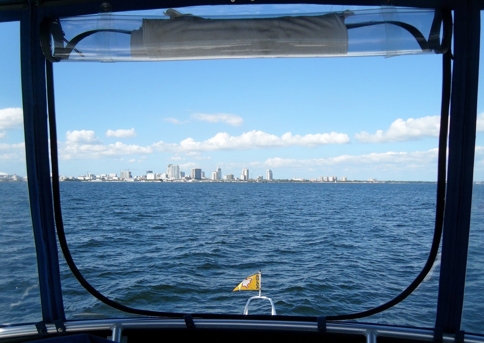
Approaching downtown St. Petersburg
And so, the saga ends in St. Petersburg. We are very glad to have had the experience. We learned a lot about other places, other people, and ourselves, but we are looking forward to settling back into life in St. Petersburg. We'll continue to live on the boat for the foreseeable future, a future which is full of possibilities that will reveal themselves in due time.

Gold Loopers Lon, Pat, and Zipper at home in
St. Petersburg
Before signing off on this final Great Loop blog entry, here are a few trip stats for the past couple of years:

2014: 4172 miles in 98 cruising days (157 calendar days), 112 locks, 1424 gallons of fuel
2015: 2062 miles in 32 cruising days (57 calendar days), 42 locks, 925 gallons of fuel.

We also cruised 341 miles during our time in St. Paul.

Grand Totals: 6575 (statute) miles, 154 locks, 2349 gallons of fuel, 130 cruising days over 214 calendar days, countless memories, extreme gratitude for a safe journey.

Thanks for following along with us. Time now for Pat to find a new hobby!

Sunday, November 1, 2015

And Then There Were Two . . .

Remaining cruising days, that is. Or maybe just one if we decide that going straight to St. Petersburg from Panama City, FL (our current port of call) is a better option for us. We arrived in Panama City yesterday, October 31, and are here until at least Tuesday while a stormy weather system passes through.

In the last blog post we were sitting out rain in Fairhope, AL. Monday the 26th was a total washout, but things improved quite a bit by Tuesday, October 27, and we were able to make our way into Fairhope for some sightseeing. Fairhope was founded in 1894 by Iowans living a real-life utopian experiment in property ownership and taxation. It later became a favorite winter destination of artists and intellectuals, and is currently a resort destination and affluent suburb of Mobile. Unlike so many of the small towns on our Great Loop route which are struggling with downtown decay, Fairhope was almost surreal in its cleanliness and lack of vacant storefronts. Something is going right here.

Still grey at Eastern Shore Marine, but at least
the rain decreased on the 27th
Sidewalk "fish art" near
 the local elementary
 school
One of MANY antique and art-related shops
in Fairhope
Lon and ice cream cone in Fairhope.
 Just OK.

Downtown Fairhope decked out for Halloween
On Wednesday, October 28 we were able to get moving again. A red letter day--after leaving Mobile Bay we entered the Intracoastal Waterway (ICW) for the first time since leaving it in northern Virginia in May 2014. And, later that morning, we entered Florida!

A pelican greets us as we enter the ICW
at Red 120
Our stop for October 28 and 29 was Pensacola, FL. There we met up with good friends from the St. Paul Yacht Club, Ron and Barb Hilson, who have a winter home in Pensacola. The city is the site of the Pensacola Naval Air Station. Ron is a retired naval aviator, so it makes perfect sense that he and Barb would choose to spend their winters there. Ron is a very skilled volunteer tour guide at the National Naval Aviation Museum, and on Thursday, October 29 we were treated to an all-day tour at the museum. Fascinating!

Former Blue Angel aircraft in the
 museum atrium. The Pensacola NAS
 is the home of the Blue Angels
Ron Hilson and Lon in the Naval Aviation Museum
Lon and Pat on the steps of the "Air Force One"
helicopter used by President Nixon to leave the
White House after his resignation in 1974
NC-4: In 1919, this became
 the first aircraft to cross the Atlantic
 Ocean (with several stops)
Aircraft awaiting restoration
Lon and Pat at dinner with Ron and Barb Hilson
On Friday, October 30 we left Pensacola and cruised about 60 miles to the Baytowne Marina at the Sandestin Resort complex near Destin, Florida. The tidal currents were not kind to us that day, so we arrived at the marina later than we would have liked--and definitely too late to take advantage of all of the resort amenities that went along with staying at the marina. 

Our dinnertime view from the Marina Grill, Baytowne
Marina
Restaurant mascot Mary Ann the
 Macaw looked
over our shoulders while we ate


On Saturday, October 31, we made an early departure from the Baytowne Marina with hopes of getting to the St. Andrews Marina in Panama City before the winds strengthened ahead of a significant storm system moving east from Texas and Louisiana. The last 15 miles on West Bay and St. Andrews Bay were somewhat choppy, but fortunately we were moving into the waves, so aside from some splash on the boat, the ride wasn't too bad.

Florida's version of "white cliffs": sand (not chalk)
lines the ICW canal between Choctawhatchee Bay and
West Bay
We are currently in the St. Andrews Marina in the '"Historic St. Andrews" neighborhood of Panama City. It's feeling very tropical at the moment--not a bad thing as far as we are concerned. 

Four-headed Pindo Palm in the city park. Said to be
the only such palm tree in the world.

Pat finding white sand in St. Andrews. It was
a tiny beach, and it wasn't on the Gulf, but it was the
best we could do without a car.
The Pelican Tree: carved from an oak killed in
a 1995 hurricane and created as a symbol of urban
renewal in St. Andrews

It now becomes a waiting game for the right weather conditions that will allow us to complete the Great Loop via a long, overnight passage across the northeastern Gulf of Mexico. Patience is the operative word.

Monday, October 26, 2015

Lasts and Firsts

As this post is being written on Monday, October 26, we are tied up snugly at Eastern Shore Marine in Fairhope, Alabama (on the eastern shore of Mobile Bay) watching the remnants of Hurricane Patricia inundate the area with rain. Still, we are very happy to be here and not stopped at some anchorage along the river. Timing is everything, and we are exactly where we had hoped to be when the days and routes were being drawn up. We had great weather when we needed it for cruising the rivers and now we have rain and wind for a couple of days when we can use the break.

It's pouring out there, and the fixed docks (the wood under the
yellow power cords) are only about 6 inches away from
being underwater.
When we left Kingfisher Bay Marina in Demopolis, AL on Friday, October 23, we knew that we wanted to be done with the river cruising and at a marina on the Gulf coast before the predicted bad weather hit. This meant boating from dawn to dusk on October 23 and 24 to keep our anchorages to two, and a similarly early start on October 25 in order to get across Mobile Bay to Fairhope as soon as possible that day. Initially we were on the Black Warrior-Tombigbee River system, and then the Mobile River. Frankly, only the names changed. The riverscape continued to be pretty and serene, but it was much the same as it had been on the Tenn-Tom--Water. Trees. Locks (but only a couple).

Hints of fall color at "Lover's Leap". The trees
at the bottom of the cliff were tenaciously growing
out of the rock.
Water like glass on October 24
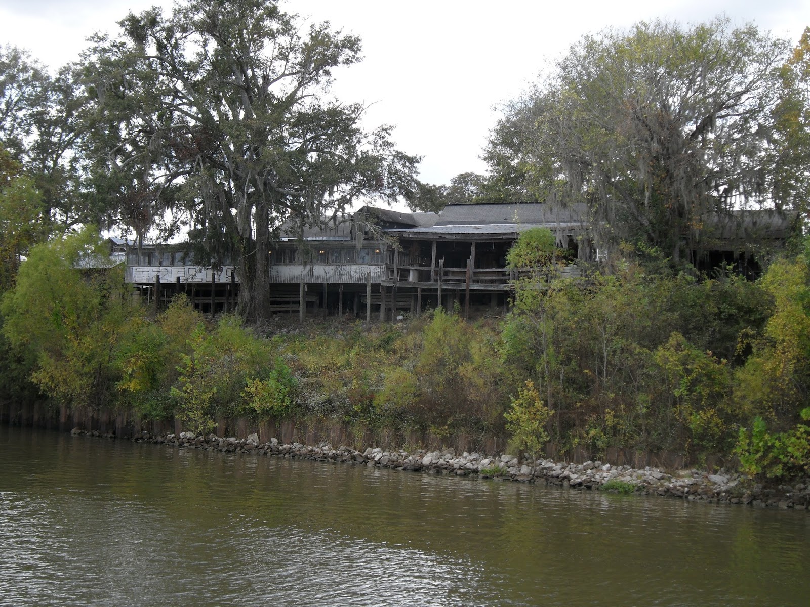
Ezell's Fish Camp, an Alabama institution. Started
in 1937 and housed in a Civil War era building, but
there was no place for a boat to tie up for lunch.
The past few days have given us some "Lasts and Firsts":

The Last Lock: Pat in the Coffeeville, AL
lock on October 24

The Last River: The Mobile skyline along the Mobile
River (and harbor) on October 25

The First Brown Pelicans: a sign of our proximity to
salt water, spotted at mile 19 on the Mobile River

The First View of Mobile Bay: a small fishing boat is at
 the foreground of the entrance to Mobile Bay. We
can imagine the Gulf of Mexico in the distance!
Getting through the harbor at Mobile and transiting to the east side of Mobile Bay were the big challenges for October 25. Mobile is a significant port city, not just for river traffic, but for ocean-going ships as well.

Meeting and passing the "Whistler Spirit" in
Mobile Harbor as it was being escorted to its
dock by pilot boats
Too many AIS targets in Mobile harbor. Good
thing most of the associated boats were docked
 and not moving
Manufacturing Navy ships

The water on Mobile Bay was a bit choppy as we left the more protected confines of the harbor. Fortunately, we didn't have too far to go. The direction of travel to the marina had us mostly meeting the waves on the bow of the boat, so we weren't rocked too much or for too long. After two nights "on the hook" it's nice to be close to a town and services.

In 27 cruising days we have completed 1603 miles, essentially all of it on various rivers. After a few more cruising days covering approximately 220 miles on the Gulf Intracoastal Waterway we should reach Appalachicola, Florida. There we will wait for a weather window that will allow us to cross the Gulf of Mexico to St. Petersburg in safety and comfort.  

Thursday, October 22, 2015

Son of Tennessee Valley Authority?

Well, not really. The Tenn-Tom (Tennessee-Tombigbee) Waterway that we cruised from Sunday, October 18 to Wednesday, October 21 was a waterway project unconnected to the TVA project on the Tennessee and Cumberland Rivers. The idea was similar, however--create a commercial waterway that could be used in lieu of the Mississippi and decrease trip distances for commercial traffic. Although the idea was first approved in 1946, the first funds weren't allocated until 1968, construction wasn't begun until 1972, and it didn't open until January 1985. It is 234 miles long and runs from the Tennessee River at Pickwick Lake in the north to the junction of the Black Warrior and Tombigbee Rivers near Demopolis, Alabama.

The past four days of cruising can be described in three words: water, trees, locks. Probably because the Tombigbee River wasn't an active commercial waterway prior to the creation of the Tenn-Tom, there aren't any towns to speak of and few marinas. It's a beautiful waterway and non-stress cruising, but after a while it's All. The. Same. So the cruising miles per day for us continues to be longer this fall than it was during our Loop last year. Fog permitting, we try to be underway by sunrise at 7 a.m. We have been disappointed that, although we are moving downstream, we don't seem to be getting much of a current assist.

Life on the Tenn-Tom: Water. Trees.

The most striking sight along the Tenn-Tom: the
White Cliffs at Epes, Alabama

Close-up of the White Cliffs. Part of the "Selma Chalk
Formation" and said to be of the same geological
age as the White Cliffs of Dover (England)

Spanish moss--we must be back in the South

With one exception, we have made our "target destination" each day. The exception was Monday, October 19. With 60 miles and four locks to complete, we needed all of the cruising elements to align. Alas, it was not to be. A foggy morning delayed our departure from Midway Marina (near Fulton, MS) for an hour. We got through the first lock of the day just fine, but for the next two found ourselves behind a slow, barge-laden tow which delayed us for at least an hour at each lock. By the time we got through the last lock at Aberdeen (thanks to a kind lock master who delayed the last pleasure craft lockage for us so that we didn't have to anchor on the upstream side of the lock) we were still 20 miles from the marina at Columbus, MS, it was late afternoon, and we were tired. We found a very peaceful anchorage off-channel 10 miles down river and spent a restful night at the Barton Ferry Cut-off. We were able to make up the other 10 miles during our cruise on Tuesday, October 20--which was another night at anchor.

Waking up to fog on the river
 on October 19 at Midway Marina
Zipper on deck at Barton Ferry
 Cut-off anchorage

Our tow boat nemesis on the 19th, Green Wave. It almost
became a problem for us on October 20 as well,
but we passed it during a crew change. Relief!

CARIB at anchor in Sumpter
 Recreational Area on October 20.
Sunrise at our anchorage in Sumpter Recreational Area.
We had one neighbor during the overnight.

Locking has been an interesting process on this waterway. Pleasure craft going through one lock together tend to have to stay grouped for subsequent lockages (as long as the locks are just a few miles apart). It doesn't help the "go fast" boats to go 30 mph because they end up waiting for the "go slow" boats to reach the locks.

Boat convoy leaving a lock. Besides these three behind us,
there were three boats in front of us.
We reached the end of the Tenn-Tom Waterway yesterday (Wednesday, October 21) and are at a very nice marina in Demopolis, Alabama for a couple of nights. Grocery shopping, laundry, cleaning, and eating out are all on the agenda. We are still awaiting word from our insurance agent about our request for a waiver to continue south of 30 degrees north latitude prior to November 1, but are hopeful it will be approved. As long as Hurricane Patricia (is it weird that I'm somewhat pleased to have a hurricane with my name?) stays in the Pacific and no tropical storms develop in the Gulf of Mexico we should be OK. As there are no marinas in the 217 miles between Demopolis and Mobile Bay, we will be anchoring out for two or three nights. Our Verizon reception has been generally terrible during our cruise this fall, so it remains to be seen how "out of touch" we will be until we reach Mobile Bay on Sunday (waiver and weather permitting).

Telephone booth in the middle of nowhere. Bet the
connectivity is better than we have with Verizon.