.jpg) |
| Betty Lou Wojtowicz: 6/18/1927 - 4/26/2014 |
Saturday, April 26, 2014
In Memorium: Betty L. Wojtowicz
We will be off the water for a few days. Lon's mom Betty died this morning in Minnesota and we will be flying there for the funeral. She was a wonderful mother and mother-in-law. After a very difficult couple of years--and 19 years of mourning Lon's dad--we are happy for her that she is now singing with the angels, but we will miss her very much.
Thursday, April 24, 2014
The Georgia Low Country and Savannah
Little development also means no marinas between St. Simon's Island (just to the north of Jekyll Island) and Savannah; therefore, we anchored out on Tuesday night. Lon found time to relax on the deck before sundown--thankfully, the breeze kept the "no see-ums" at bay for a while.
 |
| At anchor in Johnson's Creek |
On Wednesday morning we were surprised to find ourselves sharing the ICW with a cruise ship. The "Independence", a ship of the American Cruise Line, passed us heading south. Although not a large ship by cruise ship standards, we didn't think a boat with that much draft--11.5 feet--could navigate some of the sections of the ICW. Lon managed to be away from the bridge at that time, and had I been able to do a "selfie", I'm sure that I would have captured a perfect "deer in headlights" look as I steered CARIB.
 |
| The Independence passes C.A.R.I.B. II |
 |
| Beach on the ICW |
Wednesday afternoon we pulled into the Thunderbolt (GA) Marina, our home for two days. The marina is about 5 or 6 miles from downtown Savannah. There we met a couple from St. Paul whose boat we had passed on the ICW on Tuesday. We had a fun dinner with Frank and Eileen Martin at Tubby's Restaurant and Bar.
 |
| L to R: Eileen Martin, Pat, Lon, Frank Martin |
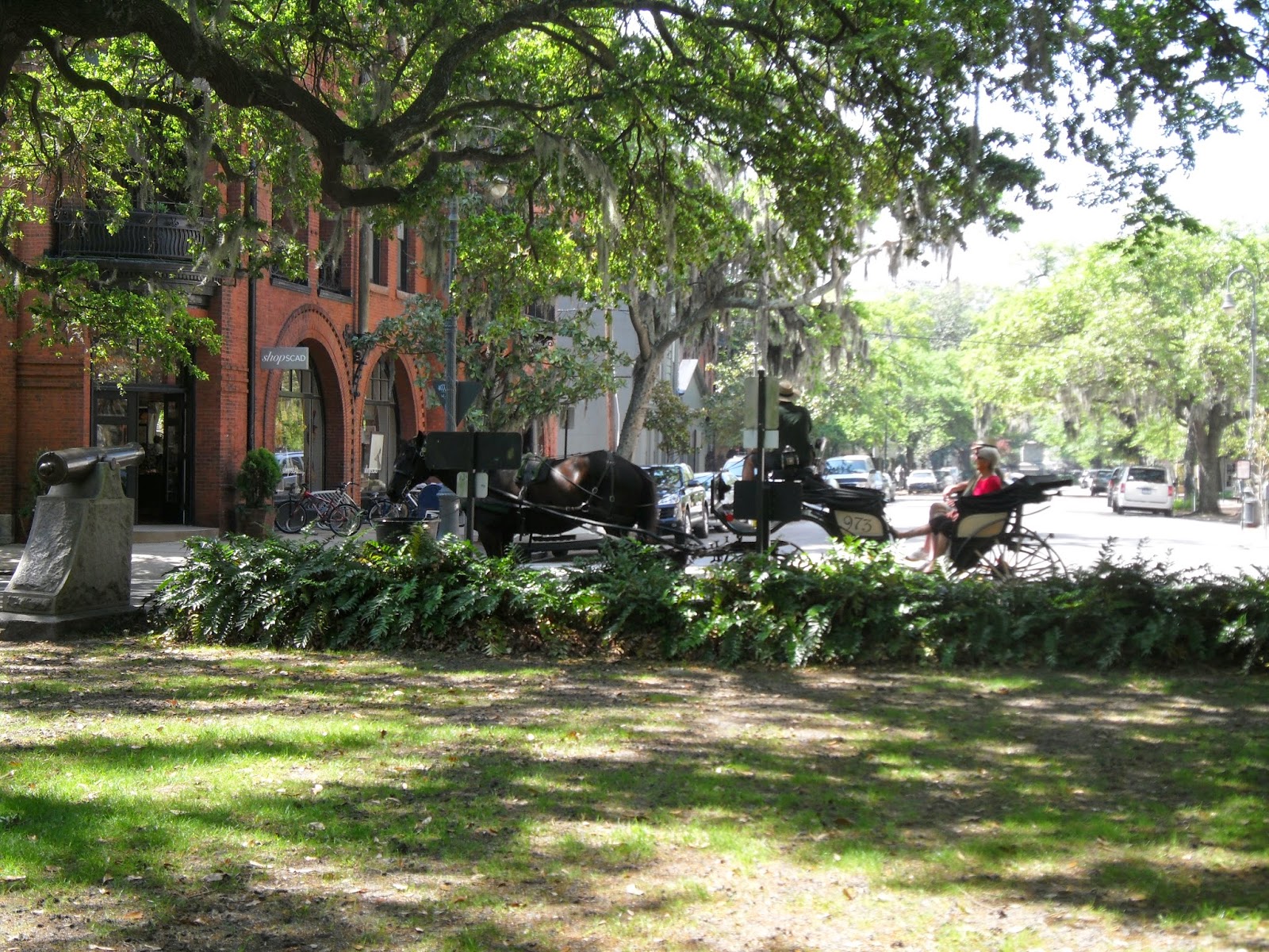 |
| Horse drawn carriage |
 |
| Typical Savannah house style |
 |
| Madison Square |
 |
| Savannah Dan in Johnson Square |
 |
| Southern Gothic |
 |
| Family plot |
 |
| Tomb of 6-year old |
Tomorrow we cross the Savannah River into South Carolina, destination Beaufort.
Monday, April 21, 2014
On the Road Again
After 3 days stretched to 5 days and then to 7, we were finally able to leave Amelia Island and start cruising again today. What crazy weather! Saturday morning and early afternoon were OK on Amelia Island, which allowed me to do some biking in the south part of the island (very green and pleasant), but thunderstorms and high winds came through later in the afternoon and through the evening. And it was colder for us on Sunday than it was in St. Paul.
But today--wow, it was fantastic. Blue skies, light winds, and calm waters took us out of Florida and up to our destination for the day, Jekyll Island in Georgia. We left about 10 a.m. on a rising tide so that we would have high enough water to get out of the Amelia Island Yacht Basin, and higher water as we wound our way up the ICW. The landscape is marsh, grass, and more marsh.
We diverged a bit from the usual Great Loop route today. The most common route for Loopers is to stay on the main ICW channel north of Cumberland Island (GA) and cross St. Andrews Sound. Because of shallow water this requires making a brief foray into the Atlantic, and it can oftentimes be a little rough. We decided not to deal with that possibility, so took an alternate inland route via Floyd's Creek and the Satilla River. It added a few miles to our day, but it went very, very well and we had no rough water to contend with--which made me very happy. We were the only boat on this route except for a rather large barge, and the captain of that vessel was nice enough to let us pass him in a relatively wide portion of the waterway.
By 3 pm we were at our berth in the Jekyll Harbor Marina on Jekyll Island. Out came our bikes and we were able to do some sightseeing. Jekyll Island is one of the "Golden Isles" of Georgia. It was a winter retreat for a select group of 100 American "captains of industry" of the late 1800's and early-mid 1900's. Not simply a single building, the Jekyll Island Club was a collection of buildings including (but not limited to) an amazing hotel and a number of mansion-sized "cottages". By 1942 the Club era was over. The island is now owned by the State of Georgia. The bike trail system is fantastic and we had a great time going through the historic district, and then to the beach, and then treating ourselves at Dairy Queen!
But today--wow, it was fantastic. Blue skies, light winds, and calm waters took us out of Florida and up to our destination for the day, Jekyll Island in Georgia. We left about 10 a.m. on a rising tide so that we would have high enough water to get out of the Amelia Island Yacht Basin, and higher water as we wound our way up the ICW. The landscape is marsh, grass, and more marsh.
 |
| Georgia marsh |
 |
| Our boating buddy in Floyd's Creek |
 |
| Jekyll Club Hotel and Croquet Court |
 |
| Indian Mound Cottage |
 |
| Pat at Jekyll Club Hotel grounds |
 |
| The beach at Great Dunes Park |
 |
| duBignon Cottage |
Thursday, April 17, 2014
Amelia Island
Florida does not seem to want to let us go. We were hoping to be underway today and across the border in Georgia, but the same crazy weather that is leaving April snow in the northland has us staying in port for at least a couple more days. We had heavy rain on Tuesday, and when that left the winds kicked up. They are still incredibly strong--20-25 mph out of the northeast, with some higher gusts. Tomorrow is supposed to bring continuing strong winds and more heavy rain. We are looking forward to continuing our journey, but we are thankful in the circumstances to be warm, comfortable, and tied up snugly at the Amelia Island Yacht Basin. Our hope at this point is to be able to leave on Saturday morning, but the weather will determine if that can happen.
We were fortunate to arrive here early enough on Monday (April 14) that we could get in a little sightseeing before the weather turned foul. The European history on Amelia Island goes back to 1562, when the French landed on the island. It is the only municipality in the US that has flown eight different national flags. Lon and I hopped on our bikes and headed toward the town of Fernandina Beach. It is a quaint, well-preserved town from the Victorian era.
 |
| Centre Street, Fernandina Beach |
 |
| Restored Victorian home |
 |
| Logging truck in Fernandina Beach |
 |
| Shrimp boat fleet |
 |
| New architecture . . . |
 |
| . . . and old |
 |
| Main Beach |
It was mentioned in a previous post that the tides can be rather large in this part of the coast. The marina we're staying in has a tide swing of about 7 feet. Because the entry channel is fairly shallow (about 3 feet at low tide), we needed to time our entry--and will need to time our exit--for a minimum of 1 hour before or after low tide. The following photos show the channel at low tide and just prior to high tide.
 |
| Marina channel at low tide |
 |
| Marina channel at high tide |
Monday, April 14, 2014
Almost Out of Florida
On Saturday, April 12, we cruised from Daytona to the historic city of St. Augustine. St. Augustine is the longest continually inhabited European-founded city in the United States. It is full of beautiful old buildings, the Castillo de San Marcos (the only 17th century fortress in existence in America), Ponce de Leon's "Fountain of Youth" (although they're really just guessing where that was), and way too many tourists for our taste. Definitely more people wandering the streets than we saw during our last visit to the city in January 2007. Having no desire to brave the crowds and revisit sites we'd already seen, we had "Happy Hour" at Meehan's Irish Pub, did a quick walk through the heart of downtown, and then returned to the boat on its mooring ball in the St. Augustine Municipal Marina for the remainder of the evening.
Fellow "Loopers" Glenn Tamguchi and Marilyn Brasier, aboard their American Tug Wabi Sabi, were also spending the night at the dock and we enjoyed refreshments and conversation on their boat.
 |
| El Galeon Andalucia-replica of a 16 C ship |
 |
| Castillo de San Marcos |
 |
| Zipper's evening in St. Augustine |
On Sunday morning, after a stop at the Vilano Beach Town Dock and a quick trip to Publix to restock our food supply, we were on our way to the Jacksonville area. Compared to previous days along the coast we saw less houses and more nature areas. As we move north the tides become more extreme. There are still palm trees, but there is quite a bit of swamp and grassy areas, and when the tide is out there is a lot of mud.
 |
| Landscape at low tide |
One canal-like region that we cruised through was notable for a couple of reasons: first, the houses fronting the canal oftentimes had elaborate boat docks and second, the watercraft traffic on this beautiful, sunny Sunday was absolutely insane. We bounced over boat wakes much of the latter part of our day.
 |
| Watercraft in front of us . . . |
 |
| Watercraft behind us . . . |
 |
| Boat shelter and waterfront patio |
After playing more "dodge the boat and/or wake" just before we crossed the St. John's River, we were happy to pull into the Jacksonville Free Dock on Sisters Creek. There we were visited by a good friend and former National Aviation Academy co-worker of Lon's-Mick Campeau. Mick now lives in Lake City, FL, about an hour west of Jacksonville, so this was a perfect opportunity to reconnect. (We previously spent time with Mick's dad during our stop in Ft. Pierce.)
 |
| Lon and Mick Campeau |
 |
| Sunset at JAX Free Dock |
Fellow "Loopers" Glenn Tamguchi and Marilyn Brasier, aboard their American Tug Wabi Sabi, were also spending the night at the dock and we enjoyed refreshments and conversation on their boat.
We are now at the last of our stops in Florida--Amelia Island. We'll be here for three nights for a bit of a break from the daily cruising, to wait out some bad weather, do a few chores, and see some of this historic area. We are also fortunate to be here at the same time as a meeting of the Marine Trawler Owners Association (MTOA), a group we recently joined. Lon will be attending one of their seminars on Wednesday. More on Amelia Island later.
P.S. Pat's mom is out of the hospital--hooray!
Friday, April 11, 2014
Manatees on the Loose!
The manatees were out in force today. At several points between Titusville and our final stop at Adventure Yacht Harbor in Wilbur by the Sea (how's that for the name of a community?) just south of Daytona Beach we saw tons of manatees-literally. We wished we had sister-in-law Sally's fancy photo equipment, because our poor little point-and-shoot camera just wasn't fast enough to capture what we saw. We did manage to photograph one manatee in the water in Haulover Canal (the cut-through in Merritt Island between the Indian River and Mosquito Lagoon).
The waterfront communities at the northern end of Mosquito Lagoon were a world away from the upscale housing we saw in the Ft. Pierce area and points south. Lots of modest houses, RV parks, and fishing camps.
One of the amusing sights of the day was the pelican that decided to "hitchhike" on a crabber's boat. It was a youngster (you can tell that by the fact that its head is still brown and not white) and must have hoped for something tasty to come out of the crab cage that it was sitting atop.
After tying up at the dock in the marina we went for a walk on the beach. It was a pretty day and a pretty beach, although a bit too crowded and developed for our taste. Interestingly, parking is allowed on sections of the beach--the sand is really hard.
Finally, we just heard that Pat's mom has gone into the hospital for some tests. We would ask for your thoughts and prayers for a quick diagnosis and a good outcome.
 |
| Manatee in the water in Haulover Canal |
 |
| RV park |
 |
| Fishing on the ICW |
One of the amusing sights of the day was the pelican that decided to "hitchhike" on a crabber's boat. It was a youngster (you can tell that by the fact that its head is still brown and not white) and must have hoped for something tasty to come out of the crab cage that it was sitting atop.
 |
| Hitchhiking pelican |
 |
| Lon on the beach at Daytona Beach Shores |
 |
| Cars on the beach |
The slogan for Daytona Beach Shores is "Life is Better Here." We're not sure if Wilbur By The Sea, a more modest community, has a city slogan, but it's probably something like "Life isn't as good here, but we have a funnier name."
 |
| Entering Wilbur By The Sea |
Thursday, April 10, 2014
Fort Pierce - Indian Harbor Beach - Titusville
The storms of Tuesday left a breezy Wednesday in their wake. Winds were blowing at 15-20 miles an hour from the north-northwest, but because they were meeting us just at an offset to our "nose", our ride was actually quite comfortable as we made our way from Ft. Pierce to the Melbourne area. The biggest impact of the wind was that it created a current that slowed us down a bit. We dropped our isinglass on the flybridge to block the wind, but all-in-all, it was a pleasant cruise. Even so, we were glad to pull into the Telemar Bay Marina in the barrier island community of Indian Harbor Beach. Located on the Banana River (an offshoot of the Indian River), it was well protected from wind and currents.
 |
| Sunset over the Banana River |
 |
| Telemar Bay Marina |
 |
| Zipper explores the dock and sees a bird |
Today (April 10) was much less windy and it was a straight shot to our next destination, Titusville, on what is called Florida's "Space Coast." The city is located very close to Cape Canaveral and the Kennedy Space Center.
 |
| Melbourne to Titusville |
Although the space shuttle program is no longer in operation, rockets still launch from Cape Canaveral. We were lucky enough to see a launch today as we neared Titusville, an "Atlas 5 rocket carrying a classified spacecraft payload for the U.S. National Reconnaissance Office."
We also had dolphins playing in the wake of the boat. No matter how many times we see dolphins it's still a thrill. We're settled in for the evening on a mooring ball at the Titusville Municipal Marina. A dinghy ride into shore allowed us to walk through the town. One of the interesting sights was Space View Park, a park honoring the contributions of space program workers.
 |
| Lon at Space View Park |
 |
| Dolphin in CARIB's wake |
 |
| On the mooring ball in Titusville |
Subscribe to:
Posts (Atom)